mikesusamoments.com
DE EN

Utah

Canyonlands Nationalpark

Endless canyons and rock terraces as far as the eye can see.

StateUtah
Park since1964
Size530 sq mi (1,366 km²)
Entrance feeabout 30 USD per vehicle (7 days), or with the America the Beautiful pass
Time to planHalf a day to a full day (Island in the Sky).

Canyonlands is vast and quiet. Where the Colorado and the Green River meet, they have carved a huge maze of gorges, mesas and towers over millions of years. The park is divided into several sections that are barely connected to one another. For most travelers, Island in the Sky is the right one, a high plateau with wide views, comfortably reached by car.

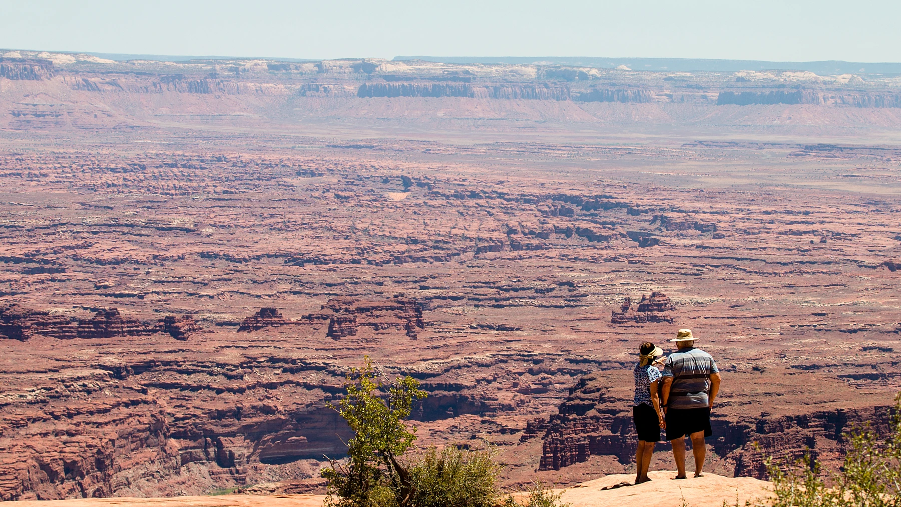
An endless sea of canyons, as far as the eye can see.

Island in the Sky

The plateau sits hundreds of meters above the land. From its edges you look out over an endless sea of canyons. The viewpoints lie close together and are easy to reach, even without a long hike.

The Mesa Arch

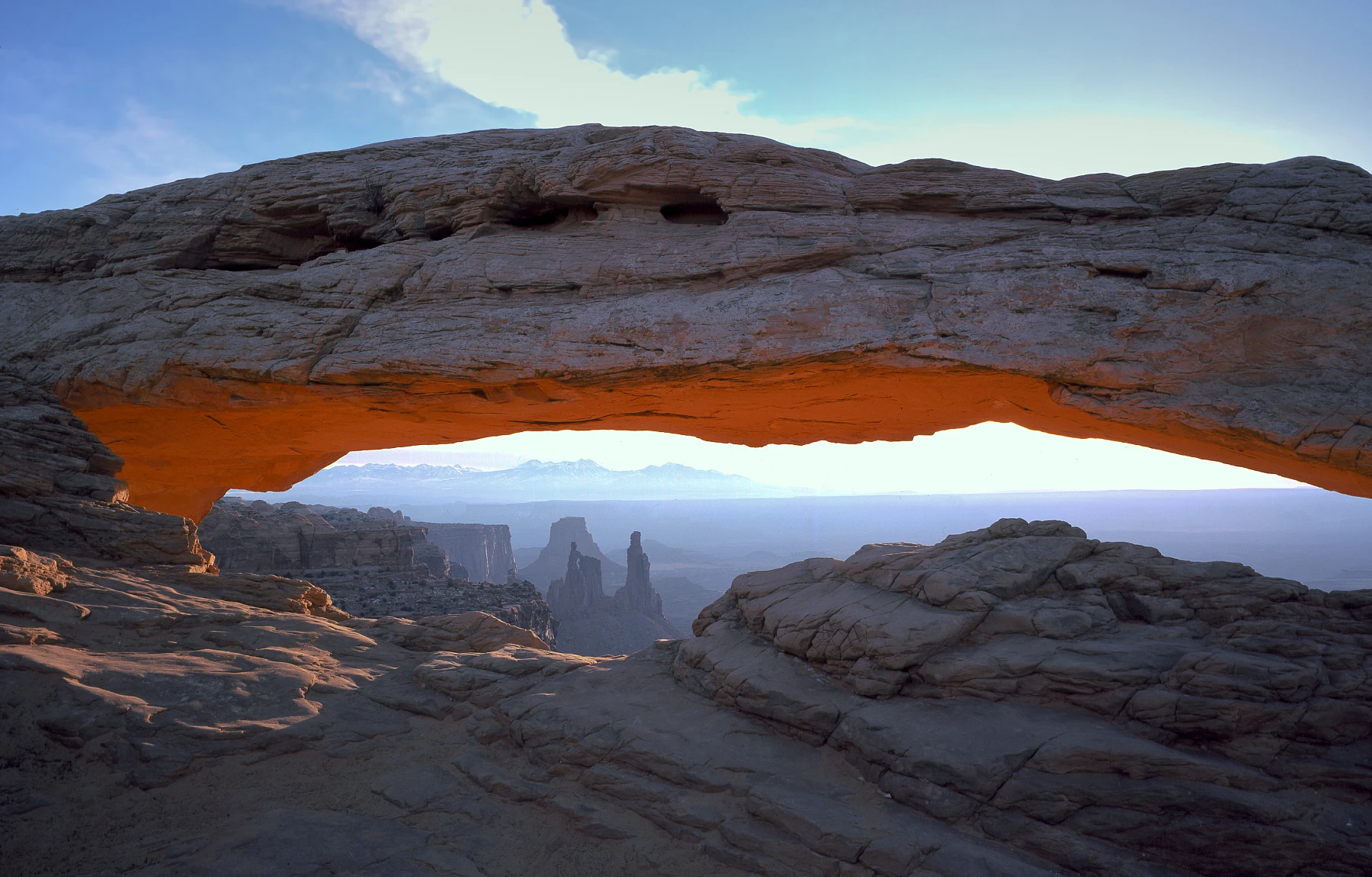
The best-known spot in the park. The low stone arch on the edge of the cliff frames the canyons behind it. At sunrise its underside glows orange-red, a picture almost every photographer wants to take once.

Wild and lonely

Canyonlands is much quieter than nearby Arches. If you prefer solitude, this is the place. The more remote sections like The Needles or The Maze are true wilderness, only for experienced and well-equipped travelers.

When to come

Spring and autumn are ideal. In summer it is hot and without shade. The Mesa Arch at sunrise is there all year, in summer just very early.

Top viewpoints

What you shouldn't miss.

Mesa Arch, Canyonlands Nationalpark
1

Mesa Arch

The famous arch on the cliff edge that glows orange-red at sunrise. A short walk, a big effect.

Directions with Google Maps
Grand View Point, Canyonlands Nationalpark
2

Grand View Point

The widest view in the park, over an endless sea of canyons. At the end of the road on Island in the Sky.

Directions with Google Maps
Island in the Sky, Canyonlands Nationalpark
3

Island in the Sky

The plateau with the great viewpoints, comfortable to drive along by car.

Directions with Google Maps
Shafer Trail, Canyonlands Nationalpark
4

Shafer Trail

A steep switchback track that leads down from the plateau into the valley. For four-wheel drive and adventurers.

Directions with Google Maps

The big questions from the forum

What was discussed most on USA-TALK.DE, with the community verdict.

Which part of Canyonlands?

For almost everyone Island in the Sky, because it is comfortable by car and has the great views. The Needles and The Maze are wilderness for the experienced.

Is the early climb to the Mesa Arch worth it?

In the forum a clear yes. When the underside of the arch begins to glow at sunrise, that is the moment you come for.

Canyonlands or rather more time in Arches?

Many combine both from Moab. Canyonlands is more spread out and quieter, Arches more compact and busier. Those who can take both.

Is the effort of the Shafer Trail by jeep worth it?

For the adventurous in the forum a clear yes. The drive over Potash Road, the Shafer Trail and back to Moab fills a whole day and shows the park from below. Those who prefer comfort stay up on Island in the Sky and at Dead Horse Point.

Practical tips from the forum

Concrete advice from travellers who were there.

Don't miss Dead Horse Point State Park. It's not part of the national park, but it sits right next door and offers one of the most spectacular overlooks in the whole area.

from the USA-TALK.DE forum

For the Shafer Trail and Potash Road an SUV with a bit of ground clearance is usually enough, but you can also rent a Jeep in Moab. The route is an adventure and takes a full day.

from the USA-TALK.DE forum

If you want to head deeper into the backcountry, say the White Rim Trail or the Needles District, check on the permit requirements ahead of time, the number of permits is limited.

from the USA-TALK.DE forum

Island in the Sky is the easy part, the viewpoints are close together and easy to reach by car. It's about 40 minutes from Moab.

from the USA-TALK.DE forum

Voices from the community

What travellers experienced on the spot.

Island in the Sky is very easy to drive by car, the viewpoints lie close together. A great show for little effort.

from the forum USA-TALK.DE

Seeing the Mesa Arch light up at sunrise, that was the classic and still overwhelming.

from the forum USA-TALK.DE

At Grand View Point we had almost silence, just vastness. After the busy Arches that felt really good.

from the forum USA-TALK.DE

When time is short I only drive to Dead Horse Point State Park. The view over the canyons is gigantic, almost nicer than some things in the national park itself.

from the forum USA-TALK.DE

We rented a Jeep Wrangler in Moab and drove down into the park via Potash Road to the Colorado and back out over the Shafer Trail. That was brilliant and filled a whole day.

from the forum USA-TALK.DE

I found Upheaval Dome on Island in the Sky fascinating, this puzzling crater where it is still not entirely clear how it formed.

from the forum USA-TALK.DE

In the Needles District we spent a night at Squaw Flat Campground. Primitive, but in an absolutely brilliant spot, right in the silence.

from the forum USA-TALK.DE

From Grand View Point the view reaches over an endless sea of canyons. We drove the viewpoints in a relaxed way by car, a great show for little effort.

from the forum USA-TALK.DE

Have you been here? Share your impression

Your experience helps other travellers more than any glossy brochure. Every post is briefly reviewed before publication.

Stay fair and on topic. I approve posts that help others.

Climate through the year

Average temperatures, day and night. Large value °C, small value °F.

43°F-7°19°F
Jan
12°54°F-3°27°F
Feb
18°64°F36°F
Mar
23°73°F43°F
Apr
29°84°F11°52°F
May
35°95°F16°61°F
Jun
38°100°F20°68°F
Jul
37°99°F19°66°F
Aug
31°88°F14°57°F
Sep
23°73°F45°F
Oct
13°55°F32°F
Nov
43°F-6°21°F
Dec

Map with viewpoints

Park, entrances and the best viewpoints at a glance.

Loading the map transfers data (including your IP address) to OpenStreetMap.

Official park map

The official National Park Service map. Zoom and pan.

Map: National Park Service, public domain.

Open map as PDF

Trails at a glance

From a short loop to a full-day hike.

TrailLengthDurationDifficultyNote
Mesa Arch Loop0.6 mi (1 km)30 mineasyShort loop to the famous arch, most beautiful at sunrise.
Grand View Point1.9 mi (3 km)1 to 1.5 hrseasyLevel along the edge of the plateau to the widest view.
Upheaval Dome1.9 mi (3 km)1.5 hrseasy to moderateTo a puzzling crater whose origin is still debated today.
Whale Rock0.6 mi (1 km)30 mineasyA short walk up a rock hump with a view all around.

Distances and driving times

How far it is to the key places nearby.

FromDistanceDrive time
Arches31 mi (50 km)approx. 40 min
Moab31 mi (50 km)approx. 40 min
Capitol Reef150 mi (240 km)approx. 2.5 hrs
Monument Valley155 mi (250 km)approx. 2.5 hrs

Where to stay

Right in the middle of things, or cheaper a bit further out.

Moab

40 minutes away

The nearest larger town with everything, a shared base for Canyonlands and Arches.

Willow Flat Campground

in the park

Only a small campground without water, simple and lonely.

Dead Horse Point State Park

on the way

Right next door, with its own viewpoint and campground.

Insider tips and common mistakes

What was worth it and what to skip.

Insider tips

  • Set off early to the Mesa Arch, before sunrise. Get into position in good time, the photo spot is in demand.
  • Take in the nearby Dead Horse Point State Park, a great viewpoint right next door.
  • Sort out fuel and water in Moab, there is nothing in the park.

Common mistakes

  • Wanting to head into The Maze or the backcountry on a whim. That is true wilderness, only with four-wheel drive, experience and a permit.
  • Hiking in the midday heat without water and shade.
  • Confusing Canyonlands with Bryce or Zion. Here it is about the vastness and the canyons.

Photos

Click to enlarge.

Canyonlands Nationalpark Canyonlands Nationalpark Canyonlands Nationalpark

Videos

The video loads from YouTube only when you click. No data flows before that.

Island in the Sky, Scenic Drive 4K

Watch on YouTube ↗

Canyonlands in 4K

Watch on YouTube ↗

The best viewpoints

Watch on YouTube ↗

Canyonlands, Island in the Sky and Mesa Arch

Watch on YouTube ↗

Frequently asked questions

Which part of Canyonlands should I visit?

For most people Island in the Sky, comfortable by car and with the great views. About 40 minutes from Moab.

When is the Mesa Arch at its best?

At sunrise, when the underside glows orange-red. Getting up early is worth it.

Can I see Canyonlands and Arches in one day?

Yes, both are near Moab. Nicer is a day each, with sunrise and sunset.

What does admission cost?

About 30 USD per vehicle for seven days, or with the America the Beautiful pass.

Nearby

Easy to combine on a road trip.

Share

Last checked . I check changeable details like entrance fees once a year.